

A Beginner’s Guide to Satellite Image Annotation in 2024
The way we understand and interact with the world has changed since satellite technology was introduced. They contain a lot of information thus; they can be used for different purposes from environmental monitoring to urban planning. However, these images only make some sense when they are accurately annotated. Such is the role played by satellite image annotation. We at Macgence specialize in offering excellent services for satellite image annotation which helps businesses and organizations to exploit geospatial data effectively. This blog will discuss why satellite image annotation matters, application areas, and how Macgence excels in providing these important services.
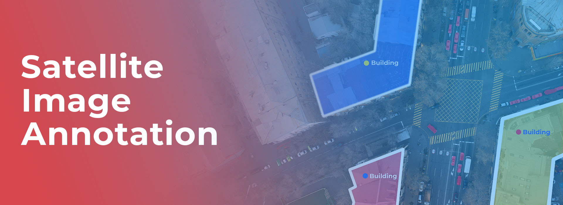
What is Satellite Image Annotation?
It is a process through which different objects or features depicted within satellite images are labeled to become understandable by machine learning algorithms. The marked dataset is later used to train AI models. That are able to recognize patterns, detect changes and come up with actionable insights out of them. The correctness and exactness of such marks determine how effective AI models become.
Why Satellite Image Annotation Matters
1.Making Better Decisions: More detailed information about accurately annotated satellite images helps in making informed decisions especially in agriculture, disaster management and urban development.
2.Monitoring Environment: Annotated satellite images enable monitoring changes like deforestation; melting glaciers or land degradation which requires timely action.
3.Infrastructure Planning: Governments and city planners use annotated satellite imagery when fetching details on infrastructure projects that facilitate sustainable development and resource allocation optimization.
4.Response to Disasters: In case of natural calamity annotated satellite images assist in relief coordination as well as planning the recovery process plus assessing the extent of damage.
5.Commercial Applications: Annotated SAT imagery could be employed by real estate businesspersons; mining industry stakeholders etc., optimize supply chains among others for site selection; resource management
Applications of Satellite Image Annotation

Agriculture: Annotated SAT images are useful for monitoring crop health, predicting yields, and managing resources. It helps to identify areas affected by pests, diseases or unfavorable weather.
Urban Planning: Annotated satellite images are analyzed by city planners for land use patterns, planning new developments and watching urban sprawl. This will help in creating sustainable cities where people can live comfortably.
Environmental Conservation: Annotated photos used by conservation institutions may assist in tracking wildlife habitats as well as evaluating the impacts of human activities on ecosystems.
Disaster Management: In disaster prone regions annotated satellite pictures are important tools used in assessing risks, designing evacuation routes and coordinating emergency responses.
Defense and Security: Military and security agencies use annotated satellite imagery for surveillance purposes, reconnaissance missions and strategic planning.
Macgence’s Expertise in Satellite Image Annotation
At Macgence we are proud of providing top quality services that meet the specific needs of our clients regarding satellite image annotation. Here is why you should choose us:
1.Advanced Annotation Tools: Our software comes with some of the best annotation tools for labeling satellite imagery accurately and efficiently. This technology guarantees high accuracy levels coupled with consistency.
2.Expert Team: We have a competent team comprising qualified annotators and geospatial experts who bring vast experience on board. They thus understand the complexities surrounding satellite imagery hence guaranteeing quality annotations.
We must ensure that we offer personalized annotation services to our clients who require it. Our services in this area extend to agriculture, urban planning and environmental monitoring sectors so as to achieve clients’ expectations.
Quality Assurance: Our work is about providing high-quality information. For us, it means carrying out our homework and ensuring that all the notes are done with precision.
Scalability: We designed our services to accommodate large projects. Thus, regardless of whether the project is small or large scale, we can deliver within budget and on time
Satellite Image Annotation Process at Macgence
Our satellite image annotation process follows some techniques that have always produced reliable and consistent results. Below is an outline of how we go about it:
Initial Consultation: Before starting off, we would like to know what you precisely want from us. Such details may include things like the kind of satellite images needed for annotation purposes and the intended attributes for annotation among others.
Data Collection and Preparation: All necessary material used in satellite image annotation including pre-processing like image enhancement typically cropping & resizing were collected.
Annotation: A team of experts in charge meticulously marks objects on images using advanced methodologies. This step is very important because it aids in producing great annotated datasets which are useful for other purposes.
Quality Control: After marking the pictures several rounds of quality checks are performed as we strive to maintain high standards since discrepancies/ errors are adjusted instantly.
Delivery and Feedback: The final dataset after completion of the whole process goes through a rigorous quality assurance process before being given out (to) its beneficiary (s). To enhance customer satisfaction, feedback mechanisms help improve service delivery by receiving timely comments from clients as well.
Advantages of Selecting Macgence
When you decide to use Macgence for your satellite image annotation requirements, you will get various advantages that can better support your usage of geospatial data:
Accuracy Level: Through perfecting the annotating job; therefore enabling more accurate decisions making processes and insights.
Efficiency: The company uses modern tools and has a skilled workforce hence time, money and so on are saved.
Scalability: We can offer scalable solutions depending on whether you have a small or large project thus ensuring timely delivery and consistency in quality.
Expert Support: Whenever you require assistance or any other guidance on how to make use of our products. We have professionals that will guide you through because we value our customer’s satisfaction from our services by providing what we believe is the maximum value for their money.
Affordability: This does not mean it is expensive but also provides less expensive flexible solutions thus giving value for your money.
In brief
Satellite image annotation is a useful feature that taps into geospatial data for many applications. Macgence has committed itself to delivering top-notch annotation services. That assist businesses and other organizations make the best use of satellite images. In agriculture, town planning or environmental protection amongst others. Our company offers required expert knowledge and support in handling satellite imagery data optimally.
FAQs
Ans: – Satellite picture labeling refers to marking different components as well as objects present in those photos taken from space. In order to make them accessible by machine learning algorithms (MLAs). It forms one stage towards training artificial intelligence models used for pattern recognition, change detection, actionable insight creation purposes.
Ans: – To draw meaningful conclusions from satellite images, one has to use satellite image annotation. It provides the data necessary for decision-making, environmental monitoring, infrastructure planning and disaster response. Amongst others thereby enhancing various business applications.
Ans: – Macgence ensures quality of its annotated satellite images through advanced tools. A squad of professional annotators, customizable facilities and strict QA processes as well as scalability across all customer segments. Our all-round approach guarantees high precision and dependability.
 Previous Blog


You Might Like

February 28, 2025
Project EKA – Driving the Future of AI in India
Spread the loveArtificial Intelligence (AI) has long been heralded as the driving force behind global technological revolutions. But what happens when AI isn’t tailored to the needs of its diverse users? Project EKA is answering that question in India. This groundbreaking initiative aims to redefine the AI landscape, bridging the gap between India’s cultural, linguistic, […]

March 7, 2025
What is Data Annotation? And How Can It Help Build Better AI?
Spread the loveIntroduction In the world of digitalised artificial intelligence (AI) and machine learning (ML), data is the core base of innovation. However, raw data alone is not sufficient to train accurate AI models. That’s why data annotation comes forward to resolve this. It is a fundamental process that helps machines to understand and interpret […]

March 6, 2025
Vertical AI Agents: Redefining Business Efficiency and Innovation
Spread the loveThe pace of industry activity is being altered by the evolution of AI technology. Its most recent advancement represents yet another level in Vertical AI systems. This is a cross discipline form of AI strategy that aims to improve automation in decision making and task optimization by heuristically solving all encompassing problems within […]
March 5, 2025
Use of Insurance Data Annotation Services for AI/ML Models
Spread the loveThe integration of artificial intelligence (AI) and machine learning (ML) is rapidly transforming the insurance industry. In order to build reliable AI/ML models, however, thorough data annotation is necessary. Insurance data annotation is a key step in enabling automated systems to read complex insurance documents, identify fraud, and optimize claim processing. If you […]